So I’ve known this concrete tube was near the house I grew up in all my life but I really never gave it a second thought. Growing up near a Minuteman II ICBM (cool wikipedia read) seems strange now but it was as normal as tractor ownership among the residents of Meade County, South Dakota.
We knew they were bad and we knew we never wanted to see them leave the bunker but besides Air Force guys driving too fast around on the gravel roads and a few war games here and there in our pastures, life around these quarter acre fenced in rocket launch pads was as normal as it could be to a grade schooler.
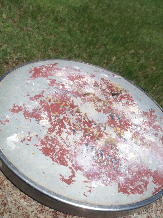
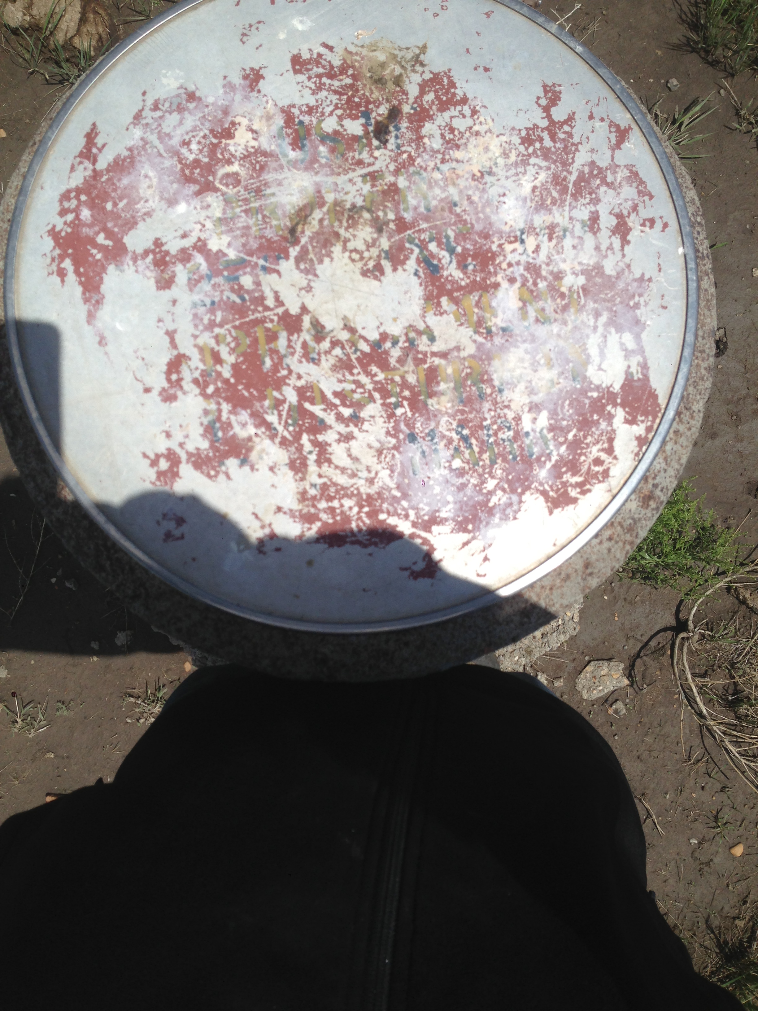
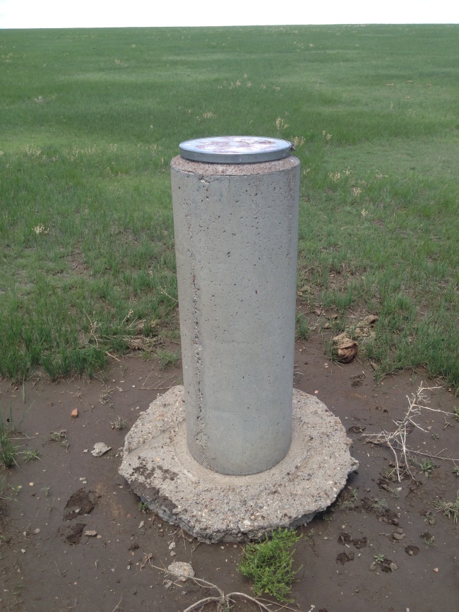
I believe I was 12 when they took old H-7 out, dismantled it and imploded the silo after the first START treaty was signed but the fence still stands to this day along with an odd cement cylinder about 200 yards away still capped with rusting steel lid with the paint flaking away still containing barely visible writing warning any who may encounter this cold war relic that “Under Penalty of the US Government, Do Not Remove”
This lonesome sentinel still guarding the prairie and reminding us a bygone era of paranoia and mutually assured destruction rekindled my attention on a recent trip home. With some research and a friend in very high places I was able to learn that what we were dealing with here is called an Azimuth Marker.
After reading about Azimuth on Wikipedia I have more questions than answers but here is what i found.
An azimuth, meaning “a way, a part, or quarter is an angular measurement in a spherical coordinate system. The vector from an observer to a point of interest is projected perpendicularly onto a reference plane; the angle between the projected vector and a reference vector on the reference plane is called the azimuth.
An example is the position of a star in the sky. The star is the point of interest, the reference plane is the horizon or the surface of the sea, and the reference vector points north. The azimuth is the angle between the north vector and the perpendicular projection of the star down onto the horizon.
Simple right?
But basically if you are looking to launch a missiles from one side of the globe to the other (spherical navigation) Azimuth is pretty damn important.
To further expound on the purpose of the concrete azimuth markers, the early Minuteman and Minuteman II systems included an actual sighting tube located down in the silo equipment room area.
The early Minuteman of which this one was, was aimed, or aligned with Polaris (The North Star) and also pointed North towards it’s then intended target. (Not Canada)
The azimuth (or alignment markers as they were commonly called) were located from 1,000 to 1,500 feet from a missile silo. This distance was the optimal distance to reduce optical error. The monuments were constructed of reinforced concrete, averaged 4 feet to 10 feet above ground, and were buried at least 10 feet in the ground.
To properly align, or sight-in the missile, a very accurate surveying instrument called a theodolite was used, which measured azimuth, degrees, minutes, seconds, arc, etc.
So before we all had GPS on our phones (and missiles) our country had the ability to launch a spaceship sized rocket from Western South Dakota out of our atmosphere, over the North Pole bringing three 500 kiloton warheads each down into Russia undoubtedly bringing unimaginable destruction and the end of modern civilization with it and they were aiming it with a scope.
And the scope looks like this. (pictures below)
There are still 450 of these bad boys buried around the great plains, I wonder if the air force even has that many Theodolites left?
If you didn’t happen to grow up playing cowboys and indians around a Nuclear missile silo and would like to find out more information about the Minuteman II or the history of the biggest, baddest part of our Nuclear Triad you can visit the National Historic Site off Interstate 90 Exit 131 in Western South Dakota near Badlands National Park, or visit them on the web at http://www.nps.gov/mimi/index.htm
* Parts of this post totally plagiarized from people who understand this stuff.
* Photos taken with iPhone 5 near Hereford, South Dakota
-Casey